01
High-resolution aerial stills
Minimum 12 frames from consistent angles. Shareable with PMs, QSs, contractors, board.
For contractors, construction directors and operations directors
Programmed flights from a fixed path. Stills, edited video, time-lapse archive. The same coordinates every month, frame-accurate continuity.
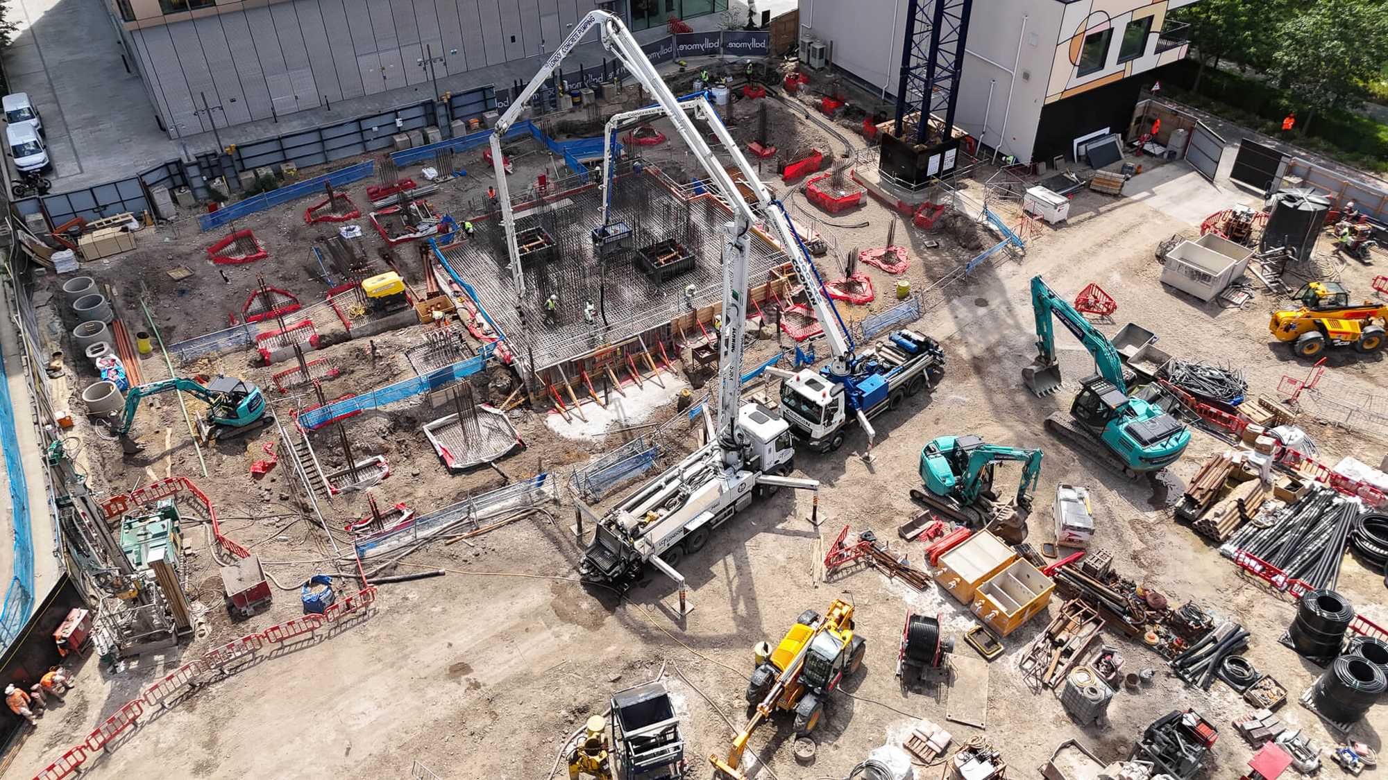
Site progress photography is fragmented. The site manager takes phone shots. The marketing team books a one-off drone flight before launch. The QS team has nothing visual to support their valuation. The board has no archive at handover.
A programmed monthly flyover replaces all of that. One flight a month. A fixed flight path captured to within a metre, every month, for the duration of the build. The same shots, the same angles, the same colour grade. Stills for site reports. Edited video for stakeholder updates. A time-lapse archive that compounds quarter by quarter.
Independent. Documented. Defensible.
The Capston at Embassy Gardens, captured top-down in Q1 2026, then again in Q2 from the exact same coordinates. A fixed flight path means every flight is frame-accurate, so progress is the only thing that changes.
01
Minimum 12 frames from consistent angles. Shareable with PMs, QSs, contractors, board.
02
Colour-graded, captioned with date, ready for stakeholder updates and investor packs.
03
Frame-accurate GPS-locked continuity from first dig to handover. Cut into a single sequence on completion.
04
Secure shared folder, accessible to everyone you nominate. No download size limits.
Programme verification across the supply chain. Subcontractor progress evidence. Visual support for monthly QS valuations. Independent site condition records for dispute and variation negotiations.
Visual timeline from groundwork to handover for board reviews, investor packs, and the post-handover archive. Consistent-angle stills that can sit alongside renders for direct comparison.
Independent third-party documentation. Time-stamped, GPS-tagged, archived monthly. Defensible evidence of claimed progress versus actual condition.
From £350 per month + VAT
Pricing scales with site size, location complexity, restricted-airspace requirements, and reporting cadence. Multi-site portfolios discounted. Procurement onboarding documents (insurance, risk assessments, method statements, CAA Operational Authorisation reference) issued at no charge.
Central London is the hardest airspace in the UK to fly in. Three Restricted Zones: R157 (Central), R158 (around Buckingham Palace), R159 (around Hyde Park). London Heliport sits at Battersea. The Metropolitan Police's Specialist Firearms Unit holds airspace authority over the diplomatic estate. The Civil Aviation Authority restricts where you can take off and land within the Charing Cross congestion area.
We hold active NATS Non-Standard Flight Permission workflows for all three Restricted Zones. We have coordinated clearances with Battersea Heliport ATC, the Metropolitan Police MPSFU, and US Embassy security on Ballymore's Embassy Gardens scheme.
If your site is anywhere inside the M25, the question is not whether we can fly. It is when.
Commercial public liability cover for drone operations and a separate production policy for ground-based work and equipment. Current Certificates of Insurance for both policies are available on request before mobilisation.
Yes. Every flight is preceded by a site-specific risk assessment and method statement, a site briefing with the SM, and an exclusion zone agreed in advance. We work around tower cranes, MEWPs, and active deliveries.
Delivered to a secure cloud folder shared with the people you nominate. We retain a working archive for 24 months for time-lapse continuity. Footage is never used in our portfolio without written consent.
We carry a 5-day rebooking window in every programme. CAA wind, visibility and precipitation thresholds are documented in the site-specific method statement. Rebooked flights do not incur additional cost.
A 20-minute call covers the site, the audience, the cadence and the cut. We send a written proposal within five working days.